I am trying to make the most of the good weather between the rainy days in this early part of rainy season by getting out and walking. I know it will soon be more sodden and a lot hotter and I won’t want to be moving around so much. So two of the last three days I have walked from home to Harajuku. It’s about 90 minutes and just under 8 km.
The first 15 minutes from home to Iidabashi is a walk I make at least twice a week. It takes me though a formerly quaint neighborhood that has been ravaged by an 8 lane highway and a building project that ate an entire five blocks of housing. The building will be the tallest on in Bunkyo-ku and will block the view of Mt Fuji from the ward office. I am not a fan.
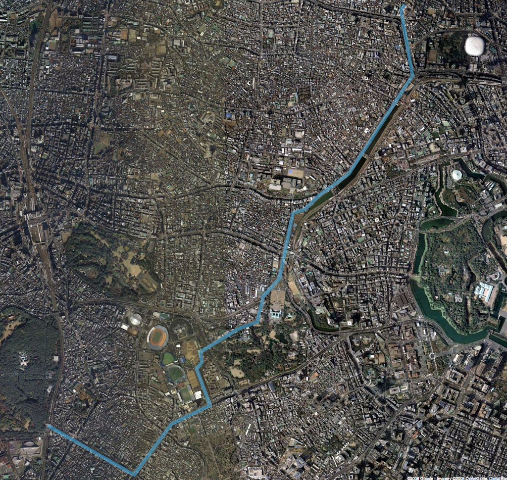
At Iidabashi, I walk along the Outer Moat down past Ichigaya Station to Yotsuya. If I walk on the canal side, with a view of the Chuo and Sobu lines across the canal, I am in Chiyoda-ku. If I walk on the building side of the street, I am in Shinjuku-ku. I prefer the tree-lined canal side as there aren’t so many pedestrians so I can walk fast, and I like the shade. But sometimes it is too buggy over there and I walk on the building side of the street. I also have the option of crossing the canal and walking along a shady park path most of the way to Yotsuya. I usually don’t do this unless I am with Tod.
At Yotsuya, I take the right fork towards the Akasaka Detached Palace. It is currently all covered in scaffolding and cloths, but usually the view of the palace through the black and gilt iron fence is quite regal. It’s only a glimpse as I walk past and then I am on a green borderland. There is a stone wall and grassy embankment punctuated with guards posted at the palace gates, and various parks and planted buildings on the other side. The stretch of the road is a big dip so I get to walk downhill part of the way, then back uphill.
At the top of the hill, I am at the side of Jingu Gyoen. Although I’d like to be able to walk straight across the grassy park, I can’t. I have to follow the road. The straightaway leading to Aoyama Itchome is lined with tall ginkgo trees. It’s beautifully formal and upright.
It’s quite a jolt to torn the corner onto Aoyama Dori. I’m back in the land of shopping and offices. From there, the route is new to me. The first day I walked it, I went straight down to Omotesando, then up to Harajuku. The route took me past all the insanely high-end shopping places and designer boutiques. The second time I walked this, I turned at Bell Commons and tried to thread my way through the back streets. But I didn’t have a map, only a mental picture and I got lost! Not so lost that I missed my destination, but I was momentarily turned around and confused. Then I spied a streetside map and headed off in the right direction.
My (very old) city atlas shows a “Japanese Traditional Crafts Center” straight across from Bell Commons. Sounds worth a look-see (unless you’re on a mission, as it sounds like you are).
It also shows a Kyu Shibuya River Promenade roughly paralleling Aoyama Dori, but closer to Meiji Dori. It looks slightly out of your way, but might be pleasant.
Sorry…you brought out the map geek in me!
Posted by: Rebecca in SoCal on June 7, 2008 09:06 AMhow long did that take you to walk?
Posted by: jav on June 11, 2008 05:19 AMJav, It took me about an hour and a half. A good walk, just getting into the “long walk” range for me.
Rebecca, I have walked along at least a section of the Kyu Shibuya River Promenade. It is pleasant!
Posted by: Kristen on June 11, 2008 10:52 AM