Mapion, my favorite online Japanese map program, launched a nifty new tool called Kyorisoku. It lets you draw out your route, then calculates all sorts of handy info about time, distance and calories.

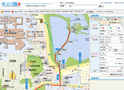
Kyorisoku Distance Calculator (click for larger view)
I marked out the walk from my house to the boat launch at Ueno Koen. It is just over 3 km, and will take me 3569 steps (not even half of my daily 10,000). I can walk there in 33 minutes if I keep a brisk pace of 5.6 km. At my current weight and age, I will burn 166 calories on the way there.
If I care less about calories and more about the amount of beer, cookies or ramen I can consume as a result of my exercise, that’s customisable, too.

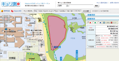
Kyorisoku Area Calculator (click for larger view)
In its other mode, which I think is somewhat less useful, you can calculate the area of anything you draw around. Not only does it give you the usual units like square meters and jo , but you’ll see how many Tokyo Domes, sheets of A4 paper or tatami mats it is, as well.
Fun Fun Fun! All in all, I think this is a very handy addition to Mapion’s other offerings. Way to go, Mapion.
Posted by kuri at August 07, 2006 02:22 PMI didn’t know about Mapion Kyorisoku even I do use Mapion whenever I need to find the way to go.
I like the idea that it shows calories! I’ll be a little bit happier if I can tell how much calories I can burn when I walk : )
ooh! I like that! I’ve been using favorite run for calculating my running/walking/biking distances, but this has many cool fun features! I’ve been tinkering with the idea of building my own because of some of favorite run’s bugs and, if I ever get the time, I will be thinking of some of these neat ideas!
Posted by: holly on August 12, 2006 01:39 AM